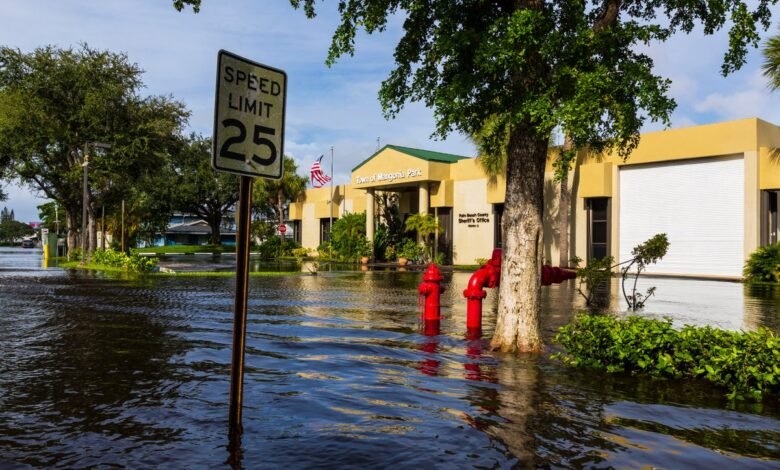
A house floating down the San Juan River in Colorado, crumbling as it crashes into a bridge. A man evacuated from a palm tree surrounded by floodwaters in Brevard County, Florida. These are scenes from the “Super El Niño”–fueled rain events that are now soaking parts of the U.S.
This week the Southwest’s Four Corners region and Florida’s central coast have experienced major flood events, swamping homes and washing out roads. It was impossible to reach meteorologists in Pagosa Springs, Colorado, by phone on Tuesday because a major fiber cable in town had been cut by flooding, bringing down cell service.
Arleen Prochazka, a retired Air Force meteorologist who co-runs the nonprofit Pagosa Weather, managed to speak with Scientific American by email Wednesday.
On supporting science journalism
If you’re enjoying this article, consider supporting our award-winning journalism by subscribing. By purchasing a subscription you are helping to ensure the future of impactful stories about the discoveries and ideas shaping our world today.
“Homes were standing essentially in lakes,” she says. Back-to-back storms have made recovery difficult, she adds. “Most roads have deep potholes and are very rutted along the edges that flowed with water, mud and debris. Many roads are still impassable.”
And it’s not just the U.S.—in recent weeks Ecuador and Peru have experienced extreme soaking rains and floods, driven by the strong El Niño and what Daniel Swain, a climate scientist at the University of California Agriculture and Natural Resources, calls “absurd” ocean warming.
“We are seeing the hydroclimate effects of a very strong El Niño event occurring now but with a boost from climate change,” Swain says.
El Niño typically brings moisture-laden air to the desert Southwest in autumn. The climate pattern also boosts precipitation in Florida from fall to spring. In that sense, these events are precisely what would be expected, given the strength of the current El Niño.
Even so, the rainfall has been historic. In Malabar, Fla., two feet of rain fell in 36 hours over November 1 and November 2, according to the National Weather Service. It was a once-in-1,000-year event for the region, meaning that there is only a one-in-1,000 chance of such an extreme rainstorm in that area in a given year. One meteorologist estimated that 1.9 trillion gallons of water fell across Florida in 24 hours.
In the Four Corners region, which spans Colorado, New Mexico, Utah and Arizona, this week’s rainfall came on top of storms that, a little more than a week ago, dumped 100-year to 1,000-year levels of rainfall on parts of all four states. Flooding along the San Juan River during that event pushed the river’s crest to 15 feet. This week flows went even higher, with a river peak at 16.81 feet in the town of Pagosa Springs, Colo. The damage comes only a year after intense October 2025 flooding, driven by the remnants of Pacific cyclones.
“Getting essentially three of these big rainstorms in two years is very unusual,” says Russ Schumacher, a meteorologist at Colorado State University and Colorado’s state climatologist.
El Niño conditions provide a favorable jet stream for these autumn storms, Swain says, but this year’s event is supercharged by a marine heat wave off the West Coast of Central and North America. “Off the coast of Baja California, the water is 11 or 12 degrees Fahrenheit warmer than average,” he says. “That is astonishing.”
Ocean temperatures are also high in the Atlantic near Florida, he says, providing local storms with a “mind-boggling amount of moisture to work with.”
The NWS Climate Prediction Center forecasts a strong to very strong El Niño from January to March 2027. Florida will likely experience a winter of severe thunderstorms, Swain says, while the risk of flooding in the U.S. West will shift to California over the next few weeks.
Source link